Shadrach S. Sheriff
GIS Analyst, DMW LOVOL Engineering Ltd., Lagos, Nigeria
Michael H. Stephenson
DDE UK
Introduction
Geographic Information System (GIS) mapping has been instrumental in many areas of geoscience, including mineral exploration, geophysics, paleontology, and hydrogeology, by enabling a spatial understanding of geological features and conveying visual information in form of maps. However, many researchers and professionals in the geosciences lack the specialized cartographic skills necessary for traditional map generation. This was my plight as well as other students during my undergraduate studies up until my early graduate days. Traditional mapping tools require extensive knowledge and technical proficiency, creating a barrier for non-experts. With advancements in technology, particularly the advent of Large Language Models (LLMs), there is an opportunity to reduce the reliance on deep cartographic expertise and democratize access to high quality mapping through open science initiatives. Traditional geological map generation tools involve complex processes and a high learning curve. These tools require systematic training and extensive experience, which not all geoscientists possess. LLMs, on the other hand, are revolutionizing this space by enabling text-based interactions for map generation, thereby reducing the need for specialized knowledge. LLMs can quickly translate natural language prompts into executable mapping actions, allowing geoscientists to focus on their core research.
Traditional Mapping Software: A High Barrier to Entry
Despite its importance, traditional GIS software is often inaccessible to many Nigerian geoscientists due to its high cost and complex functionality. Tools like ArcGIS Pro and QGIS are widely used for geological mapping but come with steep learning curves and system requirements that can be prohibitive.
ArcGIS Pro
· Cost: Subscription based model.
· High system requirements: Often necessitates a high-end computer.
· Complex UI: Not intuitive for beginners.
· Dependency: Tied to the Esri ecosystem.
QGIS
· Open source: Free to use but still has challenges.
· Learning curve: Steep for non-experts.
· Plugin dependency: Many functions rely on community developed plugins.
· Limited support: Lacks the formal support available in paid software.
The Need for AI Integration in Geoscience
LLMs have been successfully integrated across various fields to improve efficiency and accuracy. For instance, in finance, LLMs combine data analysis with risk management to provide real time investment advice. In healthcare, LLMs analyze electronic health records and medical literature to offer personalized treatment plans. The same potential exists in geoscience for tasks like data consolidation, knowledge gap identification, predictive analysis, and map generation.
A 2024 McKinsey survey revealed that AI adoption has more than doubled over the past five years, with investment rapidly increasing. Generative AI (GenAI) has become a focal point of this technological revolution. McKinsey predicts that GenAI applications could contribute up to $4.4 trillion annually to the global economy, with sectors like technology and telecommunications set to benefit greatly.

Figure 1 The state of AI in early 2024: Gen AI adoption spikes and starts to generate value
Geoscience can harness these advancements by enhancing access to geological information, allowing for the integration of historical data and the automation of mapping tasks. In this context, LLM based mapping tools hold the promise of making spatial data analysis accessible to a broader audience, from seasoned geoscientists to early career researchers.
The Map Generator: A Revolution in Map Creation
In response to these challenges, the Map Generator, powered by GeoGPT a prototype LLM developed by Deep-time Digital Earth and Zhejiang lab and not on general release, introduces an innovative approach to geological map generation. This tool utilizes text-based interaction to streamline the map creation process, allowing users to generate maps by simply typing natural language instructions. Compared to traditional software, it offers several key advantages:
· Instant Map Generation: Quick and easy.
· Standardized Layout Templates: Professional grade results.
· Flexible Instruction Interface: Adaptable to various user needs.
· Intelligent User Understanding: Minimal need for GIS knowledge.
· Precise Tool Selection: Context aware tool choices enhance accuracy.
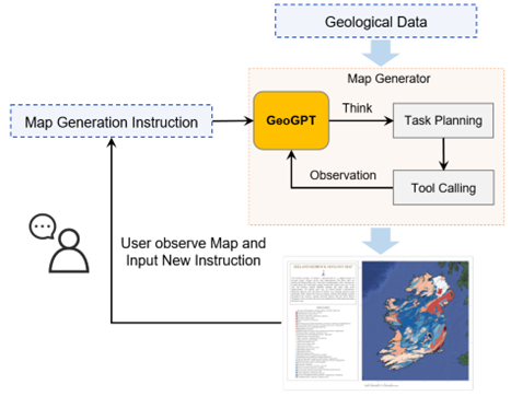
Figure 2 GeoGPT Workflow
The Map Generator integrates Chain of Thought (COT) reasoning, allowing it to translate user instructions into actionable map commands. This tool draws inspiration from MapGPT, developed by the Wuhan University team, and enhances its functionality through more focused geological mapping features.
Key Features of the Map Generator
Built on GeoGPT, the Map Generator leverages geoscience specific data and training to deliver precise, high-quality maps. Notable features include:
· Support for Extensive GIS Data: Capable of processing various file types and adding base maps.
· User Friendly Interface: Suitable for nonprofessionals.
· Built on the ArcGIS API
· Advanced Geological Map Tools: Tailored for complex geoscientific applications.
Use Case: Generating a Geological Map of Taraba, Nigeria
In a practical example, we generated a map with six (6) simple prompts…

Figure 3 Input Shapefile of Taraba, Nigeria
• I want to set the background maps as terrain map
• Modify the color ramp of the polygon features based on the NAME field by the selection.
• For LineFeatures please set the line width to 3, style as a dashed line and color as grey
• For the grid lines set their interval to 1 degree with a width of 2px and grid style to dash, color is lightblue
• Please set the legend title to 'Map Legend' with its font size to 25pt
• Please change map title to 'Geological Map of Taraba, Nigeria' with its font size to 30pt, title color is black. Please write a 170 summary of the geology of Taraba, Nigeria and set it as the map's annotation, with font size to 24pt.
Within minutes, a fully annotated geological map can be generated, complete with a summary of the region’s geology. The tool supports long text commands for multiple modifications and leverages GeoGPT’s semantic understanding to deliver precise outputs.

Figure 4 Final Output - Geological Map of Taraba, Nigeria (After NGSA, 2006)

Applications and Benefits
The Map Generator is designed to benefit both general researchers and professional cartographers. For General Researchers, no cartographic expertise is required, users can easily generate maps for academic papers, presentations, and teaching materials and it offers a low learning curve with minimal training needed to operate. For Professional Cartographers; Automatic map initialization to quickly design map prototypes, streamlined operations to simplify workflows and improve efficiency, and an enhanced focus on research were users get to spend less time on technical mapping tasks.
In both scenarios, the tool promotes the democratization of resources by providing accessible mapping technology, particularly in Nigerian geoscience.
Other Functions – GeoGPT
· Georeferencing and Point Extraction
· Table extraction
· Enhanced search and retrieval – personalized interactions
· Multi-round conversations – read documents
- Describe equations
- Gain insights from literature
Future Directions for GeoGPT and Map Generator
To continue advancing, GeoGPT and the Map Generator can focus on several areas of improvement which includes:
· Custom Solutions with Local Data: Integration with local geological data for more precise mapping.
· Enhanced Analytical Features: Adding measurement and clipping tools.
· Real-Time Learning and Adaptability: Continuously improve based on user feedback and data.
· Better Handling of Multimodal Data: Support for raster data and more complex datasets.
Conclusion
As AI and LLMs continue to evolve, their role in geoscience will only grow. Tools like the Map Generator enable researchers to perform dynamic mapping without prior GIS experience, while professional cartographers can benefit from streamlined workflows. By leveraging cloud computing and AI, the Nigerian geoscience community can drive innovation and make critical discoveries faster. Rather than replacing geoscientists, LLMs serve as valuable tools that augment existing knowledge and datasets. As we integrate LLMs like GeoGPT into the geoscience workflow, we must ensure this technology evolves responsibly, becoming a powerful ally in understanding our planet rather than a disruptive force.